I have experience with ArcMap so I decided to take a look at google my maps for its usability for new map-creating users. I have also used Google Earth in the past, which I have found very user friendly. I used that prior to ArcMap, as the latter requires a license.
I watched tutorial by Wicky Design on youtube - https://www.youtube.com/watch?v=lLJpcR5IK0.
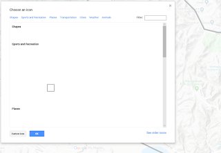
I had trouble with being able to see icons on the My Map viewer when creating the map:
One feature I would like to see is to the ability to move created points between layers. I started without a goal in mind, so I created all of my recreation points on one layer. In hindsight, it would have been nice to have hunting/fishing separate from picnic areas and wildlife viewing areas. Ideally, the wildlife viewing areas/picnic areas would be on it's own layer with hiking trails on Mainside. This feature isn't available in ArcMap either to my knowledge, nor is it available in the Avenza App (mentioned below).
Data Organization is important to make sure your markers are being placed
under the correct layer. I use the Avenza mapping App for mapping certain
things on base – mostly invasive species, but I also have a Morel mushroom
layer and maybe other edible mushroom layers. I’ve accidently placed points
in the wrong layer – this may not seem like a huge deal except for when I go
to export a layer it may end up in the wrong group, OR I delete a layer I no
longer need, but certain points were incorrectly tied to that layer,
resulting in loss of data.
It is also important to set the default view of your map. If not, every time
you open the map, google defaults to the view of the entire U.S. and you
will have to search to find the area in which your map represents.
I do like ability to add photos to a point. For example, with each of my hunter “Parking Areas”, a photo could be taken of the exact location to inform hunters of where they should park. This could be helpful in situations where an area may have dense vegetation and the road isn’t paved.
Overall, I think it's a very interesting tool and good for creating maps
for the public. After creating the map, I sent it to a friend and they
were able to see the map I created, the points I created as well as turn
layers on/off. This would be great for recreational users as they could
turn on/off a variety of layers that you had - hiking, hunting/fishing,
picnic areas, etc. I think it would have high utility in certain job
fields. I need to play around with it a little bit more as I attempted to
export a PDF and it didn't work. This would be a great feature for
planning hiking trips. However, if you don't have internet service, you
probably won't be able to access google maps. This is the advantage to
importing a georeferenced PDF into Avenza - from that app you do not need
cell phone service to have the GPS track you. I will need to see what is
going on with exporting a georeferenced PDF from google my maps to see if
I can then import this into Avenza.


No comments:
Post a Comment